IMAGES TAKEN NEAR TO
Winchester Road, LEICESTER, LE8 4HL
Introduction
This page details the photographs taken nearby to Winchester Road, LE8 4HL by members of the Geograph project.
The Geograph project started in 2005 with the aim of publishing, organising and preserving representative images for every square kilometre of Great Britain, Ireland and the Isle of Man.

There are currently over 7.5m images from over14,400 individuals and you can help contribute to the project by visiting https://www.geograph.org.uk
Image Map
Images are licensed for reuse under creativecommons.org/licenses/by-sa/2.0
Notes
- Clicking on the map will re-center to the selected point.
- The higher the marker number, the further away the image location is from the centre of the postcode.
Image Listing (9 Images Found)
Images are licensed for reuse under creativecommons.org/licenses/by-sa/2.0
Image
Details
Distance
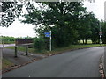
4
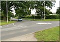
Mini roundabout in Blaby
This is the junction of Welford Road, Winchester Road and Hospital Lane.
Image: © Mat Fascione
Taken: 29 Jun 2007
0.19 miles
5
Cycle Route 6 on the outskirts of Blaby
The Route makes a detour round the centre of Blaby. This section, from Market Harborough to Leicester, is also called the Guthlaxton trail.
Image: © Tim Heaton
Taken: 23 Jul 2011
0.19 miles
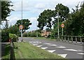
6
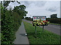
Cycle Route 6 entering Blaby along Winchester Road
Image: © Tim Heaton
Taken: 23 Jul 2011
0.21 miles
7
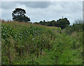
Public bridleway next to Hospital Lane in Blaby
Image: © Mat Fascione
Taken: 10 Sep 2017
0.23 miles
8
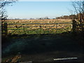
Field Entrance
What appears to be prime development land, although now (Dec 08) in the current climate it may be left undeveloped for the foreseeable future. One to revisit in a few years time.
Image: © Michael Trolove
Taken: 7 Dec 2008
0.24 miles
9
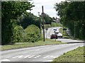
Winchester Road, Blaby
Heading south towards Countesthorpe.
Image: © Mat Fascione
Taken: 28 Jul 2007
0.24 miles