IMAGES TAKEN NEAR TO
Mill Lane, LEICESTER, LE8 4FG
Introduction
This page details the photographs taken nearby to Mill Lane, LE8 4FG by members of the Geograph project.
The Geograph project started in 2005 with the aim of publishing, organising and preserving representative images for every square kilometre of Great Britain, Ireland and the Isle of Man.

There are currently over 7.5m images from over14,400 individuals and you can help contribute to the project by visiting https://www.geograph.org.uk
Image Map
Images are licensed for reuse under creativecommons.org/licenses/by-sa/2.0
Notes
- Clicking on the map will re-center to the selected point.
- The higher the marker number, the further away the image location is from the centre of the postcode.
Image Listing (16 Images Found)
Images are licensed for reuse under creativecommons.org/licenses/by-sa/2.0
Image
Details
Distance
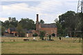
1
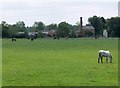
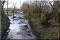
Blaby Mill near Leicester
Looking south from the towpath of the Grand Union Canal.
Image: © Mat Fascione
Taken: 24 May 2008
0.02 miles
2
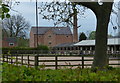
Blaby Mill stables and horse livery yard
Image: © Mat Fascione
Taken: 6 May 2017
0.02 miles
3
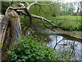
Blaby Mill
Looking south from the towpath of the Grand Union Canal.
Image: © Mat Fascione
Taken: 30 Oct 2016
0.02 miles
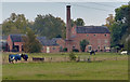
4
Blaby Mill
From the Grand Union Canal.
Image: © Andrew Abbott
Taken: 31 Aug 2020
0.03 miles
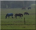
6
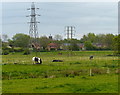
Horse paddocks near Blaby Mill
The houses are at Glen Parva, on the southern edge of Leicester.
Image: © Mat Fascione
Taken: 6 May 2017
0.15 miles
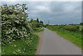
9
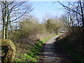
Blaby-Mill Lane
Cars can go as far as the entrance to Blaby Hill and then it becomes a footpath.
Image: © Ian Rob
Taken: 4 Mar 2011
0.19 miles