IMAGES TAKEN NEAR TO
Lapwing Lane, LEICESTER, LE8 0XR
Introduction
This page details the photographs taken nearby to Lapwing Lane, LE8 0XR by members of the Geograph project.
The Geograph project started in 2005 with the aim of publishing, organising and preserving representative images for every square kilometre of Great Britain, Ireland and the Isle of Man.

There are currently over 7.5m images from over14,400 individuals and you can help contribute to the project by visiting https://www.geograph.org.uk
Image Map
Images are licensed for reuse under creativecommons.org/licenses/by-sa/2.0
Notes
- Clicking on the map will re-center to the selected point.
- The higher the marker number, the further away the image location is from the centre of the postcode.
Image Listing (9 Images Found)
Images are licensed for reuse under creativecommons.org/licenses/by-sa/2.0
Image
Details
Distance
1
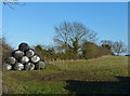
Farmland on the edge of Kibworth Beauchamp
Image: © Mat Fascione
Taken: 16 Feb 2014
0.03 miles
2
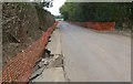
Road repairs
Warwick Road was closed at the time this photo was taken
Image: © Mat Fascione
Taken: 14 Oct 2007
0.08 miles
3
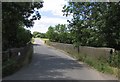
Warwick Road railway bridge
Warwick road crosses the "Midland Main Line"
Image: © Andrew Tatlow
Taken: 14 Jul 2006
0.13 miles
4
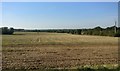
Farmland on the western edge of Kibworth
Image: © Mat Fascione
Taken: 20 Sep 2019
0.15 miles
5
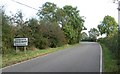
Fleckney Road towards Kibworth Beauchamp
Image: © Mat Fascione
Taken: 14 Oct 2007
0.20 miles
6
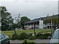
The Pavilion of Kibworth Cricket Club
As seen from the car park.
Image: © Steve Barnes
Taken: 17 Jul 2011
0.20 miles
7
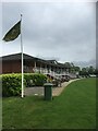
Kibworth Cricket Club Pavilion
A view of the Kibworth Crciket Club Pavilion
Image: © Clive Cartwright
Taken: 16 Jun 2019
0.20 miles
9
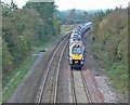
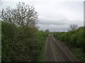
Midland Main Line
Looking north west from Warwick Road Bridge.
Image: © Mat Fascione
Taken: 14 Oct 2007
0.22 miles