IMAGES TAKEN NEAR TO
Bryars Close, LEICESTER, LE8 0RH
Introduction
This page details the photographs taken nearby to Bryars Close, LE8 0RH by members of the Geograph project.
The Geograph project started in 2005 with the aim of publishing, organising and preserving representative images for every square kilometre of Great Britain, Ireland and the Isle of Man.

There are currently over 7.5m images from over14,400 individuals and you can help contribute to the project by visiting https://www.geograph.org.uk
Image Map
Images are licensed for reuse under creativecommons.org/licenses/by-sa/2.0
Notes
- Clicking on the map will re-center to the selected point.
- The higher the marker number, the further away the image location is from the centre of the postcode.
Image Listing (32 Images Found)
Images are licensed for reuse under creativecommons.org/licenses/by-sa/2.0
Image
Details
Distance
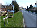
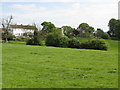
2
Weir Road, Saddington
At the junction of Shearsby Road
Image: © David Howard
Taken: 5 Mar 2023
0.04 miles
6
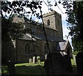
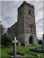
St Helen Saddington
Notice that the main entrance to the church is the north door instead of the more usual south door. The church yard on the south side is very overgrown.
Image: © Andrew Tatlow
Taken: 16 Aug 2006
0.09 miles
7
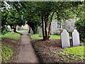
Path in St Helen's churchyard, Saddington
Image: © Mat Fascione
Taken: 29 Dec 2024
0.10 miles
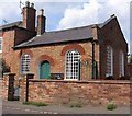
8
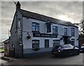
The Queens Head at Saddington
An Everards public house along the Main Street of Saddington village.
Image: © Mat Fascione
Taken: 29 Dec 2024
0.10 miles
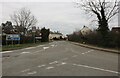
10
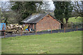
Vernacular farm building
Field barn off Kibworth Road
Image: © P Gaskell
Taken: Unknown
0.11 miles