IMAGES TAKEN NEAR TO
Main Street, LEICESTER, LE8 0QJ
Introduction
This page details the photographs taken nearby to Main Street, LE8 0QJ by members of the Geograph project.
The Geograph project started in 2005 with the aim of publishing, organising and preserving representative images for every square kilometre of Great Britain, Ireland and the Isle of Man.

There are currently over 7.5m images from over14,400 individuals and you can help contribute to the project by visiting https://www.geograph.org.uk
Image Map
Images are licensed for reuse under creativecommons.org/licenses/by-sa/2.0
Notes
- Clicking on the map will re-center to the selected point.
- The higher the marker number, the further away the image location is from the centre of the postcode.
Image Listing (20 Images Found)
Images are licensed for reuse under creativecommons.org/licenses/by-sa/2.0
Image
Details
Distance
1
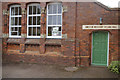
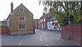
Smeeton Westerby Village Hall
Formerly the village school which closed in 1968.
Image: © Stephen McKay
Taken: 10 Aug 2015
0.05 miles
2
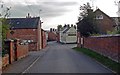
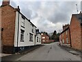
Main Street, Smeeton Westerby
The Kings Head public house is further along on the right.
Image: © Mat Fascione
Taken: 14 Oct 2007
0.05 miles
6
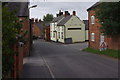
The Kings Head in Smeeton Westerby
A public house along the Main Street.
Image: © Mat Fascione
Taken: 22 Feb 2023
0.08 miles
7
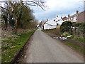
Main Street, Smeeton Westerby
Looking towards the King's Head.
Image: © Stephen McKay
Taken: 10 Aug 2015
0.09 miles

9
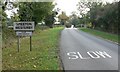
Welcome to Smeeton Westerby
Looking south along Smeeton Road.
Image: © Mat Fascione
Taken: 14 Oct 2007
0.15 miles
10
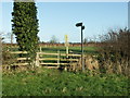
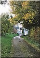
Stile on Footpath leading to Kibworth Beauchamp
Image: © Richard Williams
Taken: 1 Jan 2007
0.15 miles