IMAGES TAKEN NEAR TO
Hallaton Road, LEICESTER, LE7 9XF
Introduction
This page details the photographs taken nearby to Hallaton Road, LE7 9XF by members of the Geograph project.
The Geograph project started in 2005 with the aim of publishing, organising and preserving representative images for every square kilometre of Great Britain, Ireland and the Isle of Man.

There are currently over 7.5m images from over14,400 individuals and you can help contribute to the project by visiting https://www.geograph.org.uk
Image Map
Images are licensed for reuse under creativecommons.org/licenses/by-sa/2.0
Notes
- Clicking on the map will re-center to the selected point.
- The higher the marker number, the further away the image location is from the centre of the postcode.
Image Listing (14 Images Found)
Images are licensed for reuse under creativecommons.org/licenses/by-sa/2.0
Image
Details
Distance
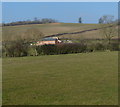
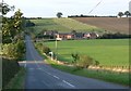
1
Chestnut Farm
The road climbing the hill is Moor Hill.
Image: © Mat Fascione
Taken: 27 Oct 2007
0.01 miles
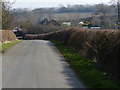
2
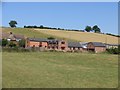
Chestnut Farm
This complex of buildings now comprises dwellings and an equestrian centre. There is no farming done from the site.
Image: © Andrew Tatlow
Taken: 18 Jul 2006
0.09 miles
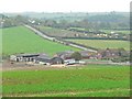
4
Farm buildings south of Ram's Head Spinney
Image: © Mat Fascione
Taken: 2 Mar 2013
0.14 miles
5
Moor Hill, Leicestershire
The junction is Crackbottle road, Chestnut Farm are the buildings to the right of the road.
Image: © Mat Fascione
Taken: 26 Aug 2007
0.15 miles
6
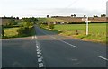
Moor Hill, Crackbottle Road junction
Chestnut Farm are the buildings visible to the right of the road.
Image: © Mat Fascione
Taken: 26 Aug 2007
0.15 miles

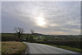
8
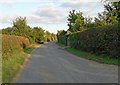
Crackbottle Road, Leicestershire
Looking back towards Rose Cottage.
Image: © Mat Fascione
Taken: 26 Aug 2007
0.17 miles
10
Towards Ram's Head Spinney
Note the letters included in the gates "FS & S"
Image: © Andrew Tatlow
Taken: 18 Jul 2006
0.20 miles