IMAGES TAKEN NEAR TO
Mowbray Drive, LE7 9LU
Introduction
This page details the photographs taken nearby to Mowbray Drive, LE7 9LU by members of the Geograph project.
The Geograph project started in 2005 with the aim of publishing, organising and preserving representative images for every square kilometre of Great Britain, Ireland and the Isle of Man.

There are currently over 7.5m images from over14,400 individuals and you can help contribute to the project by visiting https://www.geograph.org.uk
Image Map
Images are licensed for reuse under creativecommons.org/licenses/by-sa/2.0
Notes
- Clicking on the map will re-center to the selected point.
- The higher the marker number, the further away the image location is from the centre of the postcode.
Image Listing (6 Images Found)
Images are licensed for reuse under creativecommons.org/licenses/by-sa/2.0
Image
Details
Distance
1
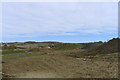
Start of groundworks for new housing development on the north side of Bushby
Starting on the later phase of Bloor Homes development of 'up to 275 dwellings and up to 500 sq m. of retail use' (Harborough District Council Planning ref 16/00874/REM).
Image: © Tim Heaton
Taken: 21 Mar 2020
0.07 miles
3
Eastern end of Flood Relief Basin from NE corner
Image: © Andrew Tatlow
Taken: 27 Jun 2016
0.22 miles
4
Eastern end of Flood Relief Basin from SE corner
Image: © Andrew Tatlow
Taken: 27 Jun 2016
0.23 miles
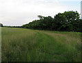
5
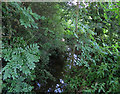
Bushby Brook upstream from footbridge
Image: © Andrew Tatlow
Taken: 27 Jun 2016
0.24 miles
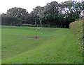
6
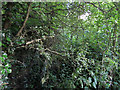
Former footpath towards Pulford Drive
The footpath was diverted to the other side of Bushby Brook and crosses it on a foot bridge.
SeeImage also.
Image: © Andrew Tatlow
Taken: 27 Jun 2016
0.24 miles