IMAGES TAKEN NEAR TO
Halstead Rise, LEICESTER, LE7 9LA
Introduction
This page details the photographs taken nearby to Halstead Rise, LE7 9LA by members of the Geograph project.
The Geograph project started in 2005 with the aim of publishing, organising and preserving representative images for every square kilometre of Great Britain, Ireland and the Isle of Man.

There are currently over 7.5m images from over14,400 individuals and you can help contribute to the project by visiting https://www.geograph.org.uk
Image Map
Images are licensed for reuse under creativecommons.org/licenses/by-sa/2.0
Notes
- Clicking on the map will re-center to the selected point.
- The higher the marker number, the further away the image location is from the centre of the postcode.
Image Listing (47 Images Found)
Images are licensed for reuse under creativecommons.org/licenses/by-sa/2.0
Image
Details
Distance
1

Tripod Crest on Marefield Lane
Sunday parking in Tilton on the Hill. Tripod Crest provide road surfacing solutions http://www.tripodcrest.co.uk/
Image: © Michael Trolove
Taken: 11 May 2014
0.04 miles
2
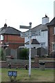
Old Direction Sign - Signpost by Oakham Road, Tilton Parish
Ball finial - 3 arms; Leicestershire simple ball by the UC road, in parish of Tilton (Harborough District), junction of Oakham Road and Marefield Lane, on large triangular verge.
Surveyed
Milestone Society National ID: LE_SK7405B.
Image: © Milestone Society
Taken: Unknown
0.06 miles
3
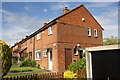
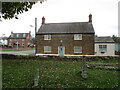
Houses on Marefield Lane
There is an OS benchmark Image on the corner, right hand face, of the near house
Image: © Roger Templeman
Taken: 19 May 2015
0.06 miles
4
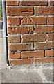
Benchmark on #18 Marefield Lane
Ordnance Survey cut mark benchmark described on the Bench Mark Database at http://www.bench-marks.org.uk/bm66863
Image: © Roger Templeman
Taken: 19 May 2015
0.06 miles
6
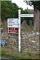
Old Direction Sign - Signpost in Tilton on the Hill
Ball finial - 4 arms; Leicestershire simple ball by the UC road, in parish of Tilton (Harborough District), junction of Main Street and Oakham Road, on verge, in front of churchyard boundary wall.
Surveyed
Milestone Society National ID: LE_SK7405C.
Image: © Milestone Society
Taken: Unknown
0.07 miles
8

Approaching Tilton on the Hill
Entering the village from the east along Oakham road.
Image: © Mat Fascione
Taken: 4 Aug 2007
0.07 miles
9
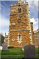
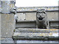
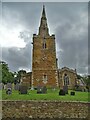
St Peter's Church and churchyard
There is an OS benchmark Image on a quoin above the shrubbery on the front of the tower at its left hand corner
Image: © Roger Templeman
Taken: 19 May 2015
0.08 miles