IMAGES TAKEN NEAR TO
Uppingham Road, LEICESTER, LE7 9HN
Introduction
This page details the photographs taken nearby to Uppingham Road, LE7 9HN by members of the Geograph project.
The Geograph project started in 2005 with the aim of publishing, organising and preserving representative images for every square kilometre of Great Britain, Ireland and the Isle of Man.

There are currently over 7.5m images from over14,400 individuals and you can help contribute to the project by visiting https://www.geograph.org.uk
Image Map
Images are licensed for reuse under creativecommons.org/licenses/by-sa/2.0
Notes
- Clicking on the map will re-center to the selected point.
- The higher the marker number, the further away the image location is from the centre of the postcode.
Image Listing (7 Images Found)
Images are licensed for reuse under creativecommons.org/licenses/by-sa/2.0
Image
Details
Distance
1

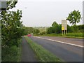
Road to Roytonel Cottage
Located along the A47 Uppingham Road.
Image: © Mat Fascione
Taken: 15 Apr 2013
0.02 miles
2

A47 Palace Hill
Heading east towards Billesdon.
Image: © Mat Fascione
Taken: 15 Apr 2013
0.08 miles
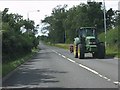
3
Palace Hill
The A47 goes eastwards towards Billesdon down Palace Hill.
Image: © Andrew Tatlow
Taken: 6 Jun 2006
0.09 miles
5

Track to Hollies Farm
Entrance located along the A47 Palace Hill.
Image: © Mat Fascione
Taken: 15 Apr 2013
0.19 miles
6

Crawler lane along the A47 Palace Hill
Looking west towards Houghton on the Hill.
Image: © Mat Fascione
Taken: 15 Apr 2013
0.20 miles
7
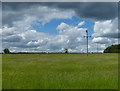
Farmland near Palace Hill
Viewed from a farm gate along Tilton Lane.
Image: © Mat Fascione
Taken: 8 Jun 2014
0.23 miles