IMAGES TAKEN NEAR TO
Harborough Road, LEICESTER, LE7 9EL
Introduction
This page details the photographs taken nearby to Harborough Road, LE7 9EL by members of the Geograph project.
The Geograph project started in 2005 with the aim of publishing, organising and preserving representative images for every square kilometre of Great Britain, Ireland and the Isle of Man.

There are currently over 7.5m images from over14,400 individuals and you can help contribute to the project by visiting https://www.geograph.org.uk
Image Map
Images are licensed for reuse under creativecommons.org/licenses/by-sa/2.0
Notes
- Clicking on the map will re-center to the selected point.
- The higher the marker number, the further away the image location is from the centre of the postcode.
Image Listing (7 Images Found)
Images are licensed for reuse under creativecommons.org/licenses/by-sa/2.0
Image
Details
Distance
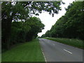
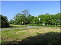
1
B6047 Harborough Road
Quite a busy road, from Market Harborough to Melton Mowbray.
Image: © Robin Webster
Taken: 18 Jul 2021
0.07 miles
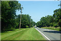
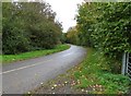
2
Illston Lane Junction with B6047
Melton to the left and Market Harborough to the right.
Image: © Andrew Tatlow
Taken: 2 Jun 2006
0.07 miles
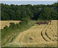
4
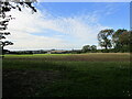
Autumn sown crop near Cranhill Farm
Looking towards Frisby.
Image: © Jonathan Thacker
Taken: 6 Oct 2021
0.13 miles