IMAGES TAKEN NEAR TO
Forge End, LEICESTER, LE7 7NY
Introduction
This page details the photographs taken nearby to Forge End, LE7 7NY by members of the Geograph project.
The Geograph project started in 2005 with the aim of publishing, organising and preserving representative images for every square kilometre of Great Britain, Ireland and the Isle of Man.

There are currently over 7.5m images from over14,400 individuals and you can help contribute to the project by visiting https://www.geograph.org.uk
Image Map
Images are licensed for reuse under creativecommons.org/licenses/by-sa/2.0
Notes
- Clicking on the map will re-center to the selected point.
- The higher the marker number, the further away the image location is from the centre of the postcode.
Image Listing (37 Images Found)
Images are licensed for reuse under creativecommons.org/licenses/by-sa/2.0
Image
Details
Distance
1
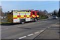
Fire engine on Hallfields Lane, Rothley
Image: © Mat Fascione
Taken: 13 Mar 2016
0.09 miles
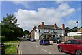
3
The Blue Bell at Rothley
A public house on Town Green Street.
Image: © Mat Fascione
Taken: 15 Apr 2018
0.10 miles
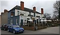
4
81 Town Green Street, Rothley
The farmyard end of the building with the large carriage entrance into the yard and the range of outbuildings visible beyond. The estate agent's notice refers to development of 4 new dwellings as well as conversion of existing farm buildings. Listed Grade II.
Image: © Alan Murray-Rust
Taken: 8 Sep 2013
0.11 miles
5
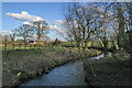
The Rothley Brook
Looking NE along this small river, which is a tributary of the River Soar.
Image: © Kate Jewell
Taken: 1 Mar 2006
0.12 miles
6
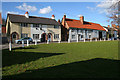
Town Green, Rothley, Leicestershire
One of two greens in this village this is a large triangular area of grass with a huge tree in the centre. There are cottages on two sides and parkland on the third. See http://www.genuki.org.uk/big/eng/LEI/Rothley.html for information. This is the historical centre of the village.
Image: © Kate Jewell
Taken: 1 Mar 2006
0.12 miles
7
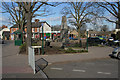
Cross Green, Rothley
The War Memorial at the commercial centre of this large village. See http://www.leicestershirevillages.com/rothley
Image: © Kate Jewell
Taken: 1 Mar 2006
0.12 miles
8
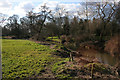
Rothley Brook
Looking sw, upstream towards Rothley Park
Image: © Kate Jewell
Taken: 1 Mar 2006
0.12 miles
9
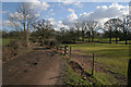
Rothley Park, Leicestershire
This farm road leads across extensive parkland towards Southfields Farm Image and on to Thurcaston Image
Image: © Kate Jewell
Taken: 1 Mar 2006
0.12 miles
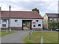
10
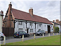
81 Town Green Street, Rothley
Formerly Park Farm. A 17th century timber-framed former farmhouse with attached outbuildings. Listed Grade II.
Image: © Alan Murray-Rust
Taken: 8 Sep 2013
0.12 miles