IMAGES TAKEN NEAR TO
Grangefields Drive, LEICESTER, LE7 7ND
Introduction
This page details the photographs taken nearby to Grangefields Drive, LE7 7ND by members of the Geograph project.
The Geograph project started in 2005 with the aim of publishing, organising and preserving representative images for every square kilometre of Great Britain, Ireland and the Isle of Man.

There are currently over 7.5m images from over14,400 individuals and you can help contribute to the project by visiting https://www.geograph.org.uk
Image Map
Images are licensed for reuse under creativecommons.org/licenses/by-sa/2.0
Notes
- Clicking on the map will re-center to the selected point.
- The higher the marker number, the further away the image location is from the centre of the postcode.
Image Listing (6 Images Found)
Images are licensed for reuse under creativecommons.org/licenses/by-sa/2.0
Image
Details
Distance
1
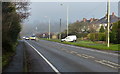
A6 Loughborough Road in Rothley
The road is heading north towards Mountsorrel.
Image: © Mat Fascione
Taken: 4 Jan 2015
0.12 miles
2
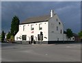
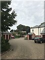
Red Lion in Rothley
Public house on the corner of Loughborough Road and Cossington Lane.
Image: © Mat Fascione
Taken: 15 Jun 2008
0.17 miles
4
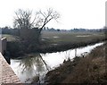
Rothley Brook from Farnham Bridge
View SW from Farnham bridge.
Image: © David P Howard
Taken: 26 Jan 2010
0.22 miles
6
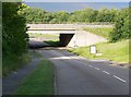
Cossington Lane in Rothley
Passing under the A6 Loughborough Road.
Image: © Mat Fascione
Taken: 15 Jun 2008
0.25 miles