IMAGES TAKEN NEAR TO
Leicester Road, LEICESTER, LE7 7JH
Introduction
This page details the photographs taken nearby to Leicester Road, LE7 7JH by members of the Geograph project.
The Geograph project started in 2005 with the aim of publishing, organising and preserving representative images for every square kilometre of Great Britain, Ireland and the Isle of Man.

There are currently over 7.5m images from over14,400 individuals and you can help contribute to the project by visiting https://www.geograph.org.uk
Image Map
Images are licensed for reuse under creativecommons.org/licenses/by-sa/2.0
Notes
- Clicking on the map will re-center to the selected point.
- The higher the marker number, the further away the image location is from the centre of the postcode.
Image Listing (13 Images Found)
Images are licensed for reuse under creativecommons.org/licenses/by-sa/2.0
Image
Details
Distance
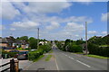
2
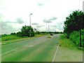
Houses on Leicester Road, Thurcaston
A view from a Great Central Railway train.
Image: © Robin Webster
Taken: 25 Mar 2016
0.11 miles
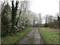
3
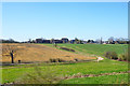
Field entrance off Leicester Road, Thurcaston
There are plans to develop the land beyond the existing line of housing with a major expansion of the City of Leicester.
Image: © Jonathan Thacker
Taken: 12 Mar 2023
0.15 miles
4
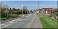
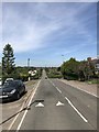
Welcome to Thurcaston
Leicester Road in Thurcaston near Leicester.
Image: © Mat Fascione
Taken: 5 Apr 2007
0.16 miles
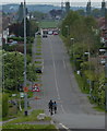
7
Leicester Road entering Thurcaston from the south-east
Image: © Tim Heaton
Taken: 25 May 2023
0.18 miles
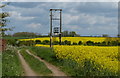
9
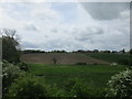
View towards Thurcaston
Taken from the Great Central Railway.
Image: © Jonathan Thacker
Taken: 20 May 2016
0.22 miles