IMAGES TAKEN NEAR TO
Lavender Close, LEICESTER, LE7 7HZ
Introduction
This page details the photographs taken nearby to Lavender Close, LE7 7HZ by members of the Geograph project.
The Geograph project started in 2005 with the aim of publishing, organising and preserving representative images for every square kilometre of Great Britain, Ireland and the Isle of Man.

There are currently over 7.5m images from over14,400 individuals and you can help contribute to the project by visiting https://www.geograph.org.uk
Image Map
Images are licensed for reuse under creativecommons.org/licenses/by-sa/2.0
Notes
- Clicking on the map will re-center to the selected point.
- The higher the marker number, the further away the image location is from the centre of the postcode.
Image Listing (19 Images Found)
Images are licensed for reuse under creativecommons.org/licenses/by-sa/2.0
Image
Details
Distance
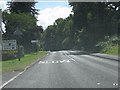
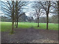
4

Stelle Way, Glenfield
Leading to Gynsills Hall off Gynsill Lane.
Image: © Richard Vince
Taken: 9 Mar 2024
0.12 miles
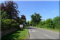
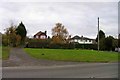
5

Gynsill Lane, Glenfield (2)
At its junction with Stelle Way, looking towards Anstey.
Image: © Richard Vince
Taken: 9 Mar 2024
0.13 miles
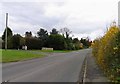
9

Gynsill Lane, Glenfield (1)
Approaching its junction with Stelle Way, looking towards Anstey.
Image: © Richard Vince
Taken: 9 Mar 2024
0.14 miles
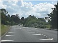
10
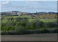
Fields next to Gynsill Lane
Looking north across Rothley Brook towards the higher ground of Bradgate Park.
Image: © Mat Fascione
Taken: 15 Apr 2014
0.16 miles