IMAGES TAKEN NEAR TO
Cawley Field, LEICESTER, LE7 7HW
Introduction
This page details the photographs taken nearby to Cawley Field, LE7 7HW by members of the Geograph project.
The Geograph project started in 2005 with the aim of publishing, organising and preserving representative images for every square kilometre of Great Britain, Ireland and the Isle of Man.

There are currently over 7.5m images from over14,400 individuals and you can help contribute to the project by visiting https://www.geograph.org.uk
Image Map
Images are licensed for reuse under creativecommons.org/licenses/by-sa/2.0
Notes
- Clicking on the map will re-center to the selected point.
- The higher the marker number, the further away the image location is from the centre of the postcode.
Image Listing (31 Images Found)
Images are licensed for reuse under creativecommons.org/licenses/by-sa/2.0
Image
Details
Distance
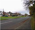
2
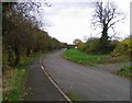
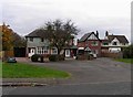
Gorse Hill
Formerly this was part of Anstey Lane which had to be diverted when the Leicester Western Bypass was constructed.
Image: © Andrew Tatlow
Taken: 13 Nov 2012
0.04 miles
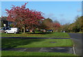
3
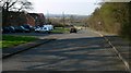
Gorse Hill. Anstey is visible in the distance.
Image: © Mat Fascione
Taken: 1 Apr 2007
0.04 miles
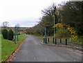
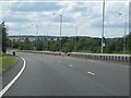
9
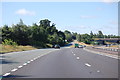
A46 slip road for A5630
The exit also gives access to Anstey to the north
Image: © J.Hannan-Briggs
Taken: 18 Jul 2015
0.12 miles