IMAGES TAKEN NEAR TO
Stamford Drive, LEICESTER, LE7 7HJ
Introduction
This page details the photographs taken nearby to Stamford Drive, LE7 7HJ by members of the Geograph project.
The Geograph project started in 2005 with the aim of publishing, organising and preserving representative images for every square kilometre of Great Britain, Ireland and the Isle of Man.

There are currently over 7.5m images from over14,400 individuals and you can help contribute to the project by visiting https://www.geograph.org.uk
Image Map
Images are licensed for reuse under creativecommons.org/licenses/by-sa/2.0
Notes
- Clicking on the map will re-center to the selected point.
- The higher the marker number, the further away the image location is from the centre of the postcode.
Image Listing (10 Images Found)
Images are licensed for reuse under creativecommons.org/licenses/by-sa/2.0
Image
Details
Distance
1
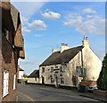
The White Lodge in Cropston
A Grade II listed property on Station Road.
Image: © Mat Fascione
Taken: 2 Oct 2016
0.19 miles
2

Cropston Road, Cropston near Leicester
Cropston has grown into a substantial village. These houses are on Waterfield Road.
Image: © Kate Jewell
Taken: 20 Dec 2005
0.19 miles
3
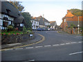
Station Road Cropston
From the main village crossroads looking east along Station Road, which does indeed lead to the station - Rothley Station, about a mile away for an easy commute to Leicester or Loughborough.
Image: © Trevor Rickard
Taken: 8 Aug 2009
0.22 miles
4
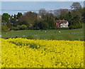
View across farmland to Thurcaston village
Looking east across the shallow Rothley Brook valley from Cropston Road.
Image: © Mat Fascione
Taken: 26 Apr 2015
0.22 miles
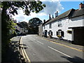
5
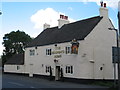
The Bradgate Arms in Cropston
This 400-year-old public house is on Station Road in the village of Cropston.
Image: © Mat Fascione
Taken: 7 Apr 2020
0.22 miles
6
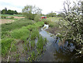
Rothley Brook next to the Coffin Bridge
Image: © Mat Fascione
Taken: 17 May 2020
0.23 miles
7
Cropston Bradgate Arms
15 Station Road.
Image: © the bitterman
Taken: 17 Jul 2010
0.23 miles
8
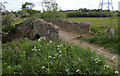
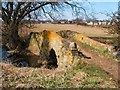
Coffin Bridge crossing the Rothley Brook
This 16th or 17th Century packhorse bridge is Grade II listed, it carries a public bridleway across Rothley Brook. It is said to be so named because the track was used to take coffins from Cropston to Thurcaston Church.
Image: © Mat Fascione
Taken: 17 May 2020
0.24 miles
9
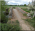
Public bridleway crossing the Coffin Bridge
This 16th or 17th Century packhorse bridge is Grade II listed, it carries a public bridleway across Rothley Brook. It is said to be so named because the track was used to take coffins from Cropston to Thurcaston Church.
Image: © Mat Fascione
Taken: 17 May 2020
0.24 miles