IMAGES TAKEN NEAR TO
Link Road, LEICESTER, LE7 7BY
Introduction
This page details the photographs taken nearby to Link Road, LE7 7BY by members of the Geograph project.
The Geograph project started in 2005 with the aim of publishing, organising and preserving representative images for every square kilometre of Great Britain, Ireland and the Isle of Man.

There are currently over 7.5m images from over14,400 individuals and you can help contribute to the project by visiting https://www.geograph.org.uk
Image Map
Images are licensed for reuse under creativecommons.org/licenses/by-sa/2.0
Notes
- Clicking on the map will re-center to the selected point.
- The higher the marker number, the further away the image location is from the centre of the postcode.
Image Listing (7 Images Found)
Images are licensed for reuse under creativecommons.org/licenses/by-sa/2.0
Image
Details
Distance
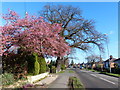
2
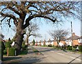
Fairhaven Road, Anstey
This is the northerly reach of the Village. Fairhaven Farm is just beyond the hedge on the right.
Image: © Kate Jewell
Taken: 14 Nov 2005
0.12 miles
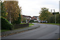
3
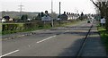
Cropston Road, Anstey
The junction with King Williams Way is visible on the left.
Image: © Mat Fascione
Taken: 1 Apr 2007
0.12 miles
4
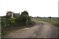
Fairhaven Farm, Anstey
This farm is on the Northern-most edge of Anstey. The hills on the horizon are in Bradgate Park, the home of Lady Jane Grey, whose family were associated with Anstey.
Image: © Kate Jewell
Taken: 14 Nov 2005
0.20 miles
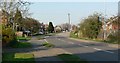
6
Looking south along Cropston Road into Anstey.
Image: © Mat Fascione
Taken: 1 Apr 2007
0.21 miles
7
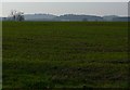
Looking across farmland towards Bradgate Park
The photo was taken just north of Anstey, on Cropston Road.
Image: © Mat Fascione
Taken: 1 Apr 2007
0.25 miles