IMAGES TAKEN NEAR TO
Rotherby Lane, LEICESTER, LE7 4WN
Introduction
This page details the photographs taken nearby to Rotherby Lane, LE7 4WN by members of the Geograph project.
The Geograph project started in 2005 with the aim of publishing, organising and preserving representative images for every square kilometre of Great Britain, Ireland and the Isle of Man.

There are currently over 7.5m images from over14,400 individuals and you can help contribute to the project by visiting https://www.geograph.org.uk
Image Map
Images are licensed for reuse under creativecommons.org/licenses/by-sa/2.0
Notes
- Clicking on the map will re-center to the selected point.
- The higher the marker number, the further away the image location is from the centre of the postcode.
Image Listing (20 Images Found)
Images are licensed for reuse under creativecommons.org/licenses/by-sa/2.0
Image
Details
Distance
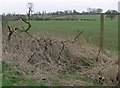
2
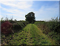
Farmland near Gaddesby, Leicestershire
Evening sunshine gives a warm glow to the hedgerows on a very cold first day of Spring!
Image: © Kate Jewell
Taken: 22 Mar 2006
0.11 miles
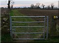
6
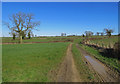
Entrance to field east of Rotherby Road
Image: © Andrew Tatlow
Taken: 9 Mar 2017
0.16 miles
8
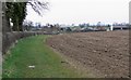
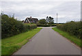
Farmland near Gaddesby
The houses in the distance are part of the village of Gaddesby.
Image: © Mat Fascione
Taken: 15 Mar 2009
0.18 miles