IMAGES TAKEN NEAR TO
Paudy Lane, LEICESTER, LE7 4TA
Introduction
This page details the photographs taken nearby to Paudy Lane, LE7 4TA by members of the Geograph project.
The Geograph project started in 2005 with the aim of publishing, organising and preserving representative images for every square kilometre of Great Britain, Ireland and the Isle of Man.

There are currently over 7.5m images from over14,400 individuals and you can help contribute to the project by visiting https://www.geograph.org.uk
Image Map
Images are licensed for reuse under creativecommons.org/licenses/by-sa/2.0
Notes
- Clicking on the map will re-center to the selected point.
- The higher the marker number, the further away the image location is from the centre of the postcode.
Image Listing (3 Images Found)
Images are licensed for reuse under creativecommons.org/licenses/by-sa/2.0
Image
Details
Distance
1

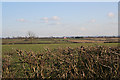
Wolds landscape
Grey clouds and gaunt trees on Seagrave Wolds.
Image: © Alan Murray-Rust
Taken: 25 Nov 2011
0.12 miles
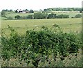
2
Seagrave Wolds, Leicestershire
Looking SE from Berrycroft Lane. Traffic on the A 46 Fosse Way can be seen in the distance. This major route and Roman Road crosses the square in the far SE corner.
Image: © Kate Jewell
Taken: 4 Mar 2006
0.22 miles
3
View across Seagrave Wolds
Looking north from the A46 Fosse Road towards Mount Pleasant Farm, with the small wood known as Cradock's Ashes beyond.
Image: © Mat Fascione
Taken: 28 Jun 2008
0.24 miles