IMAGES TAKEN NEAR TO
Ratcliffe Road, LEICESTER, LE7 4SP
Introduction
This page details the photographs taken nearby to Ratcliffe Road, LE7 4SP by members of the Geograph project.
The Geograph project started in 2005 with the aim of publishing, organising and preserving representative images for every square kilometre of Great Britain, Ireland and the Isle of Man.

There are currently over 7.5m images from over14,400 individuals and you can help contribute to the project by visiting https://www.geograph.org.uk
Image Map
Images are licensed for reuse under creativecommons.org/licenses/by-sa/2.0
Notes
- Clicking on the map will re-center to the selected point.
- The higher the marker number, the further away the image location is from the centre of the postcode.
Image Listing (15 Images Found)
Images are licensed for reuse under creativecommons.org/licenses/by-sa/2.0
Image
Details
Distance
1
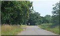
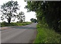
The eastern end of Humble Lane
The junction is with Ratcliffe Road; a track continues the line of Humble Lane on the other side of the junction.
Image: © David Smith
Taken: 22 Jul 2013
0.03 miles
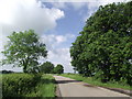

7
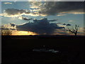
Humbles Sunset
Taken from Humble Lane, Sileby
Image: © Eric Garner
Taken: 28 Feb 2006
0.19 miles
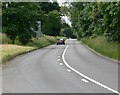
9
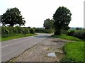
Blackberry Lane near Sileby
A byway.
Image: © Jonathan Thacker
Taken: 12 Mar 2023
0.20 miles