IMAGES TAKEN NEAR TO
Blackberry Lane, LEICESTER, LE7 4SE
Introduction
This page details the photographs taken nearby to Blackberry Lane, LE7 4SE by members of the Geograph project.
The Geograph project started in 2005 with the aim of publishing, organising and preserving representative images for every square kilometre of Great Britain, Ireland and the Isle of Man.

There are currently over 7.5m images from over14,400 individuals and you can help contribute to the project by visiting https://www.geograph.org.uk
Image Map
Images are licensed for reuse under creativecommons.org/licenses/by-sa/2.0
Notes
- Clicking on the map will re-center to the selected point.
- The higher the marker number, the further away the image location is from the centre of the postcode.
Image Listing (22 Images Found)
Images are licensed for reuse under creativecommons.org/licenses/by-sa/2.0
Image
Details
Distance
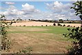
1
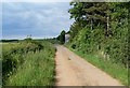
Blackberry Lane near Sileby, Leicestershire
Humbles Farm is visible further along on the right.
Image: © Mat Fascione
Taken: 15 Jun 2008
0.03 miles
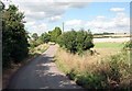
2

Field east of Cossington
North west of Blackberry Lane.
Image: © Richard Vince
Taken: 19 Jun 2021
0.06 miles
3
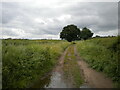
Blackberry Lane east of Cossington (1)
Image: © Richard Vince
Taken: 19 Jun 2021
0.07 miles
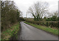
4
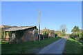
Blackberry Lane passing Barn Lodge
On the Leicestershire Round
Image: © Tim Heaton
Taken: 2 Dec 2021
0.08 miles
5
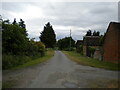
Blackberry Lane east of Cossington (2)
Passing Barn Lodge.
Image: © Richard Vince
Taken: 19 Jun 2021
0.08 miles
9

South west end of Blackberry Lane, east of Cossington
Image: © Richard Vince
Taken: 19 Jun 2021
0.21 miles
10
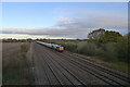
Class 66 diesel taking gravel down the Midland Main Line past Cossington
Image: © Tim Heaton
Taken: 2 Dec 2021
0.21 miles