IMAGES TAKEN NEAR TO
South Croxton Road, LEICESTER, LE7 4RD
Introduction
This page details the photographs taken nearby to South Croxton Road, LE7 4RD by members of the Geograph project.
The Geograph project started in 2005 with the aim of publishing, organising and preserving representative images for every square kilometre of Great Britain, Ireland and the Isle of Man.

There are currently over 7.5m images from over14,400 individuals and you can help contribute to the project by visiting https://www.geograph.org.uk
Image Map
Images are licensed for reuse under creativecommons.org/licenses/by-sa/2.0
Notes
- Clicking on the map will re-center to the selected point.
- The higher the marker number, the further away the image location is from the centre of the postcode.
Image Listing (35 Images Found)
Images are licensed for reuse under creativecommons.org/licenses/by-sa/2.0
Image
Details
Distance
3

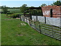
Derelict building by Station Road
Google Streetview shows this building complete with roof in 2009.
Image: © Andrew Tatlow
Taken: 21 Mar 2012
0.06 miles
4
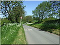
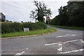
Station Road south of Barsby
Approaching the crossroads with Twyford Road.
Image: © Mat Fascione
Taken: 26 May 2012
0.07 miles