IMAGES TAKEN NEAR TO
Whitcroft Close, MARKFIELD, LE67 9SH
Introduction
This page details the photographs taken nearby to Whitcroft Close, LE67 9SH by members of the Geograph project.
The Geograph project started in 2005 with the aim of publishing, organising and preserving representative images for every square kilometre of Great Britain, Ireland and the Isle of Man.

There are currently over 7.5m images from over14,400 individuals and you can help contribute to the project by visiting https://www.geograph.org.uk
Image Map
Images are licensed for reuse under creativecommons.org/licenses/by-sa/2.0
Notes
- Clicking on the map will re-center to the selected point.
- The higher the marker number, the further away the image location is from the centre of the postcode.
Image Listing (14 Images Found)
Images are licensed for reuse under creativecommons.org/licenses/by-sa/2.0
Image
Details
Distance
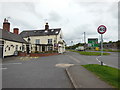
1
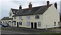
Coach & Horses
A public house along the A50 in Markfield.
Image: © Mat Fascione
Taken: 8 Mar 2009
0.18 miles
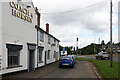
3
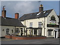
Field Head Coach & Horses
Everards pub on the A50 close to Markfield.
Image: © the bitterman
Taken: 21 Mar 2010
0.19 miles
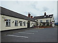
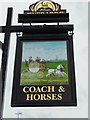
6
The Coach & Horses, Markfield
The Coach & Horses is an old coaching inn standing back from the busy A50 on its own service road. It is part of the Everard's estate.
Image: © Stephen McKay
Taken: 17 Sep 2021
0.20 miles
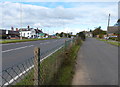
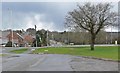
9
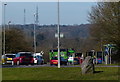
Traffic on the busy A50 at Markfield
On the horizon are the two communications masts at Copt Oak.
Image: © Mat Fascione
Taken: 8 Feb 2015
0.21 miles
10
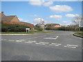
Entrance to Ratby Lane from Maunde Road in Markfield
Image: © Peter Robinson
Taken: 6 Apr 2013
0.23 miles