IMAGES TAKEN NEAR TO
Markfield Lane, MARKFIELD, LE67 9PS
Introduction
This page details the photographs taken nearby to Markfield Lane, LE67 9PS by members of the Geograph project.
The Geograph project started in 2005 with the aim of publishing, organising and preserving representative images for every square kilometre of Great Britain, Ireland and the Isle of Man.

There are currently over 7.5m images from over14,400 individuals and you can help contribute to the project by visiting https://www.geograph.org.uk
Image Map
Images are licensed for reuse under creativecommons.org/licenses/by-sa/2.0
Notes
- Clicking on the map will re-center to the selected point.
- The higher the marker number, the further away the image location is from the centre of the postcode.
Image Listing (8 Images Found)
Images are licensed for reuse under creativecommons.org/licenses/by-sa/2.0
Image
Details
Distance
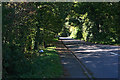
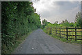
1
Leicestershire Round path near John's Lee Cottage
Image: © Mat Fascione
Taken: 2 Jun 2020
0.07 miles
2
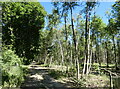
Leicestershire Round path through John's Lee Wood
Image: © Mat Fascione
Taken: 2 Jun 2020
0.09 miles
3
Leicestershire Round path near John's Lee Cottage
Image: © Mat Fascione
Taken: 2 Jun 2020
0.15 miles
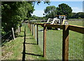
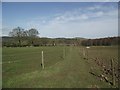
4
Tangle-Trees Wood
Part of the National Forest, Tangle-Trees Wood, to the left, is an old established woodland while on the right is the brand new Bailey Sim Wood. This farm road and bridleway leads to John's Lee Wood.
Image: © Kate Jewell
Taken: 20 Jul 2006
0.16 miles
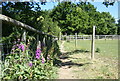
5
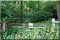
Tangle-Trees Wood
It's advisable to stick to the public rights of way round here.
Image: © Kate Jewell
Taken: 20 Jul 2006
0.16 miles
6
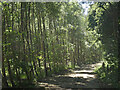
Leicestershire Round path through John's Lee Wood
Image: © Mat Fascione
Taken: 2 Jun 2020
0.17 miles
7
Footpath from Field Head to John's Lee Wood
Image: © Tim Glover
Taken: 2 Apr 2016
0.20 miles