IMAGES TAKEN NEAR TO
Ulverscroft Lane, MARKFIELD, LE67 9PL
Introduction
This page details the photographs taken nearby to Ulverscroft Lane, LE67 9PL by members of the Geograph project.
The Geograph project started in 2005 with the aim of publishing, organising and preserving representative images for every square kilometre of Great Britain, Ireland and the Isle of Man.

There are currently over 7.5m images from over14,400 individuals and you can help contribute to the project by visiting https://www.geograph.org.uk
Image Map
Images are licensed for reuse under creativecommons.org/licenses/by-sa/2.0
Notes
- Clicking on the map will re-center to the selected point.
- The higher the marker number, the further away the image location is from the centre of the postcode.
Image Listing (6 Images Found)
Images are licensed for reuse under creativecommons.org/licenses/by-sa/2.0
Image
Details
Distance
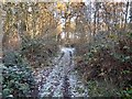

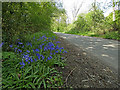
4
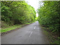
Ulverscroft Lane
Craven's Rough is the wood to the left.
Image: © Nigel Cox
Taken: 20 May 2006
0.16 miles

6
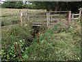
Foot bridge over Ulverscroft Brook in Lea Meadows Nature Reserve
Image: © Tim Glover
Taken: 22 Aug 2016
0.19 miles