IMAGES TAKEN NEAR TO
Stordon Lane, COALVILLE, LE67 8US
Introduction
This page details the photographs taken nearby to Stordon Lane, LE67 8US by members of the Geograph project.
The Geograph project started in 2005 with the aim of publishing, organising and preserving representative images for every square kilometre of Great Britain, Ireland and the Isle of Man.

There are currently over 7.5m images from over14,400 individuals and you can help contribute to the project by visiting https://www.geograph.org.uk
Image Map
Images are licensed for reuse under creativecommons.org/licenses/by-sa/2.0
Notes
- Clicking on the map will re-center to the selected point.
- The higher the marker number, the further away the image location is from the centre of the postcode.
Image Listing (7 Images Found)
Images are licensed for reuse under creativecommons.org/licenses/by-sa/2.0
Image
Details
Distance
2
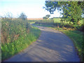
Stordon Lane
View south-west up the hill as the narrow lane threads through mixed farmland.
Image: © Trevor Rickard
Taken: 29 Aug 2009
0.12 miles
3
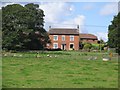
Meadows around Elms Farm
View north-east across several meadows to the farm buildings and a large stack of fresh straw bales. Large crop of elderberries in the hedgerow here.
Image: © Trevor Rickard
Taken: 29 Aug 2009
0.14 miles
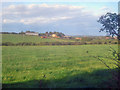
5
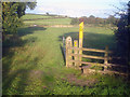
Footpath junction near Griffydam
Looking east across a set of meadows at the junction of public footpaths. Elms Farm on the horizon.
Image: © Trevor Rickard
Taken: 29 Aug 2009
0.18 miles
6
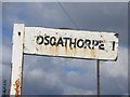
Finger Post
Wooden finger with plastic letters tacked on fastened to a piece of angle iron stuck in the ground.
Image: © Andrew Tatlow
Taken: 7 Sep 2006
0.18 miles
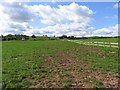
7
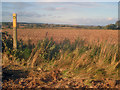
Path junction near Stordon Grange
Looking north-west across arable land. The cooling towers of Ratcliffe power station on the horizon.
Image: © Trevor Rickard
Taken: 29 Aug 2009
0.24 miles