IMAGES TAKEN NEAR TO
Jeffcoats Lane, COALVILLE, LE67 8QE
Introduction
This page details the photographs taken nearby to Jeffcoats Lane, LE67 8QE by members of the Geograph project.
The Geograph project started in 2005 with the aim of publishing, organising and preserving representative images for every square kilometre of Great Britain, Ireland and the Isle of Man.

There are currently over 7.5m images from over14,400 individuals and you can help contribute to the project by visiting https://www.geograph.org.uk
Image Map
Images are licensed for reuse under creativecommons.org/licenses/by-sa/2.0
Notes
- Clicking on the map will re-center to the selected point.
- The higher the marker number, the further away the image location is from the centre of the postcode.
Image Listing (23 Images Found)
Images are licensed for reuse under creativecommons.org/licenses/by-sa/2.0
Image
Details
Distance
1
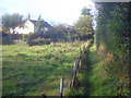
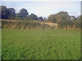
Ivanhoe Way at Swannington Common
Heading north to emerge on Jeffcoats Lane behind the house.
Image: © Trevor Rickard
Taken: 29 Aug 2009
0.06 miles
2
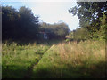
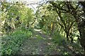
Footpath at Swannington Common
Looking north along the Ivanhoe Way, which is not well-signed in this area.
Image: © Trevor Rickard
Taken: 29 Aug 2009
0.06 miles
3
Leicester to Swannington Railway
Part of the line near 'the sidings'.The incline is sited behind me.
Image: © Ashley Dace
Taken: 21 May 2012
0.07 miles
4
Leicester to Swannington Railway
The Leicester and Swannington Railway (L&S) was one of England's first railways, being opened on 17 July 1832 to bring coal from collieries in west Leicestershire to Leicester.
Image: © Ashley Dace
Taken: 21 May 2012
0.09 miles
5
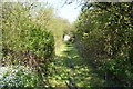
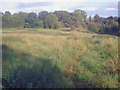
Ivanhoe Way at Swannington Common
Looking north-east across several small meadows.
http://www.leics.gov.uk/index/environment/countryside/walking/ivanhoeway.htm
Image: © Trevor Rickard
Taken: 29 Aug 2009
0.12 miles
6
Leicester to Swannington Railway
The Leicester and Swannington Railway (L&S) was one of England's first railways, being opened on 17 July 1832 to bring coal from collieries in west Leicestershire to Leicester.
Image: © Ashley Dace
Taken: 21 May 2012
0.13 miles
7
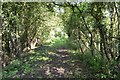
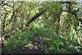
Meadow at Swannington Common
Looking east along the public footpath, which heads through long grass to the yellow post on the other side of the field. The tree-line is the old railway track to Calcutta Pit, which is just off picture to the left.
Image: © Trevor Rickard
Taken: 29 Aug 2009
0.14 miles
8
Leicester to Swannington Railway
The Leicester and Swannington Railway (L&S) was one of England's first railways, being opened on 17 July 1832 to bring coal from collieries in west Leicestershire to Leicester.
Image: © Ashley Dace
Taken: 21 May 2012
0.17 miles
9
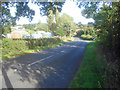
Church Hill
Looking south-east along Church Hill with Jeffcoats Lane joining from the left.
Image: © Trevor Rickard
Taken: 29 Aug 2009
0.19 miles
10
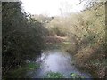
Flooded trackbed of the former Coleorton Railway
The Coleorton railway has been disused since 1872, giving plenty time for the drainage to fail.
Image: © Ian Calderwood
Taken: 9 Apr 2015
0.20 miles