IMAGES TAKEN NEAR TO
Ashby Road, COALVILLE, LE67 8PB
Introduction
This page details the photographs taken nearby to Ashby Road, LE67 8PB by members of the Geograph project.
The Geograph project started in 2005 with the aim of publishing, organising and preserving representative images for every square kilometre of Great Britain, Ireland and the Isle of Man.

There are currently over 7.5m images from over14,400 individuals and you can help contribute to the project by visiting https://www.geograph.org.uk
Image Map
Images are licensed for reuse under creativecommons.org/licenses/by-sa/2.0
Notes
- Clicking on the map will re-center to the selected point.
- The higher the marker number, the further away the image location is from the centre of the postcode.
Image Listing (17 Images Found)
Images are licensed for reuse under creativecommons.org/licenses/by-sa/2.0
Image
Details
Distance
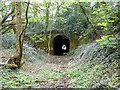
1
The south-east portal of Newbold tunnel
The south-east portal of Newbold tunnel. It was built originally for the Coleorton Railway, a line which used horse haulage, opened in 1833 and closed in 1872. The tunnel was refurbished in 1925 for use by the branch to New Lount colliery, which in turn closed in 1968, when the line was abandoned once more.
Image: © Richard Green
Taken: 15 Apr 2011
0.05 miles
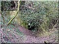
3
The north-west portal of Newbold tunnel
The north-west portal of Newbold tunnel. It was built originally for the Coleorton Railway, opened in 1833 and closed in 1872. The tunnel was refurbished in 1925 for use by the branch to New Lount colliery, which closed in 1968, when the line was abandoned once more. The tunnel is dry inside and in generally good condition - a tribute to its builders.
Image: © Richard Green
Taken: 15 Apr 2011
0.08 miles
4
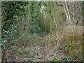
Twice-abandoned railway at Newbold
This section of railway was originally built as part of the Coleorton Railway, opened in 1833 and closed in 1860. It was reopened in 1924 to connect the newly-sunk New Lount colliery with the LMSR line from Ashby-de-la-Zouch to Derby. When the colliery closed in 1968 the line was closed and lifted for the second time.
Image: © Richard Green
Taken: 19 Mar 2011
0.09 miles
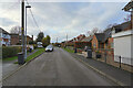
5
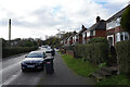
Newbold Village
It is obviously the day for collecting rubbish in this village as all the dustbins are out awaiting emptying.
Image: © Malcolm Neal
Taken: 6 Dec 2022
0.09 miles
6
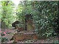
Derelict weighbridge on approach to Newbold tunnel
The remains of two weighbridges in the cutting approaching Newbold tunnel. The line, which served New Lount colliery, closed when the mine closed in 1968. These walls are the remains of the two weighbridges that weighed the wagons individually as they passed over the bridge. The loaded waggons pulled by the train passed by the weighbridges and into the tunnel before reversing back over them.
Image: © Richard Green
Taken: 15 Apr 2011
0.10 miles

8
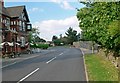
Worthington Lane in Newbold
The building on the left is The Cross Keys pub.
Image: © Mat Fascione
Taken: 26 Jul 2008
0.11 miles
9
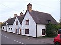
Elms Farmhouse
Elms Farmhouse is Grade 2 listed.
Image: © Ian Calderwood
Taken: 31 Oct 2014
0.12 miles
10
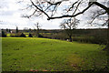
Farmland at Newbold
Just off Worthington Lane and Pipeyard Lane this countryside falls away to the line of an old railway. The farm in the distance is in Image
Image: © Kate Jewell
Taken: 21 Mar 2007
0.12 miles