IMAGES TAKEN NEAR TO
Dryer Close, IBSTOCK, LE67 6RG
Introduction
This page details the photographs taken nearby to Dryer Close, LE67 6RG by members of the Geograph project.
The Geograph project started in 2005 with the aim of publishing, organising and preserving representative images for every square kilometre of Great Britain, Ireland and the Isle of Man.

There are currently over 7.5m images from over14,400 individuals and you can help contribute to the project by visiting https://www.geograph.org.uk
Image Map
Images are licensed for reuse under creativecommons.org/licenses/by-sa/2.0
Notes
- Clicking on the map will re-center to the selected point.
- The higher the marker number, the further away the image location is from the centre of the postcode.
Image Listing (7 Images Found)
Images are licensed for reuse under creativecommons.org/licenses/by-sa/2.0
Image
Details
Distance
1
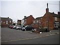
Car park off High Street, Ibstock
Located on the corner of Gladstone Street, opposite the Whimsey Inn.
Image: © Richard Vince
Taken: 27 Mar 2013
0.18 miles
2
Ibstock Post Office
Located on High Street near the south end of the village centre.
Image: © Richard Vince
Taken: 27 Mar 2013
0.18 miles
3
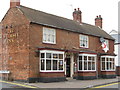
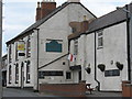
Ibstock Whimsey Inn
92 High Street. Plain red brick village local.
Image: © the bitterman
Taken: 29 Jul 2010
0.18 miles
4
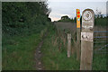
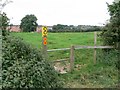
Footpath in Grange Wood
The extensive footpath system is clearly marked in this part of the National Forest
Image: © Kate Jewell
Taken: 4 Oct 2006
0.21 miles
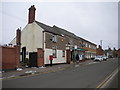
6
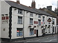
Ibstock Boot Inn
37 Gladstone Street. Side street village local.
Image: © the bitterman
Taken: 29 Jul 2010
0.24 miles
7
Ibstock Ram Inn
High Street. Previously called the Ram Hotel.
Image: © the bitterman
Taken: 29 Jul 2010
0.24 miles