IMAGES TAKEN NEAR TO
West Walk, IBSTOCK, LE67 6PL
Introduction
This page details the photographs taken nearby to West Walk, LE67 6PL by members of the Geograph project.
The Geograph project started in 2005 with the aim of publishing, organising and preserving representative images for every square kilometre of Great Britain, Ireland and the Isle of Man.

There are currently over 7.5m images from over14,400 individuals and you can help contribute to the project by visiting https://www.geograph.org.uk
Image Map
Images are licensed for reuse under creativecommons.org/licenses/by-sa/2.0
Notes
- Clicking on the map will re-center to the selected point.
- The higher the marker number, the further away the image location is from the centre of the postcode.
Image Listing (15 Images Found)
Images are licensed for reuse under creativecommons.org/licenses/by-sa/2.0
Image
Details
Distance
2
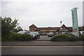
The Co-operative store on Ashby Road, Ibstock
Image: © Ian S
Taken: 27 Jul 2021
0.12 miles
3
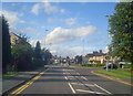
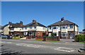
Melbourne Road
At the junction with Maple Drive looking north along the village main street.
Image: © Trevor Rickard
Taken: 15 Aug 2009
0.13 miles
4
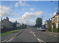
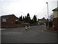
Ibstock crossroads
Looking north along Melbourne Road. Ashby Road running left-to-right.
Image: © Trevor Rickard
Taken: 15 Aug 2009
0.16 miles
5
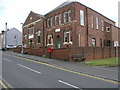
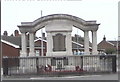
Baptist Church
The church is the building on the left. The building on the right is equal in size and the stone tablet states that this is the Sunday School.
Image: © Michael Patterson
Taken: 24 May 2006
0.17 miles
7
South end of Chapel Street, Ibstock
Seen from its junction with Curzon Street (right) and High Street (out of frame to the left).
Image: © Richard Vince
Taken: 27 Mar 2013
0.21 miles

10
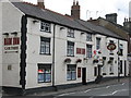
Ibstock Ram Inn
High Street. Previously called the Ram Hotel.
Image: © the bitterman
Taken: 29 Jul 2010
0.22 miles