IMAGES TAKEN NEAR TO
Farley Crescent, IBSTOCK, LE67 6AN
Introduction
This page details the photographs taken nearby to Farley Crescent, LE67 6AN by members of the Geograph project.
The Geograph project started in 2005 with the aim of publishing, organising and preserving representative images for every square kilometre of Great Britain, Ireland and the Isle of Man.

There are currently over 7.5m images from over14,400 individuals and you can help contribute to the project by visiting https://www.geograph.org.uk
Image Map
Images are licensed for reuse under creativecommons.org/licenses/by-sa/2.0
Notes
- Clicking on the map will re-center to the selected point.
- The higher the marker number, the further away the image location is from the centre of the postcode.
Image Listing (18 Images Found)
Images are licensed for reuse under creativecommons.org/licenses/by-sa/2.0
Image
Details
Distance
1
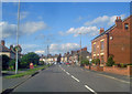
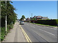
Bend in Melbourne Road
Main village street bending off to the left.
Image: © Trevor Rickard
Taken: 15 Aug 2009
0.08 miles
2
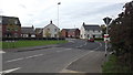
Usbourne Way, Ibstock
A new housing estate on the edge of Ibstock
Image: © John Welford
Taken: 23 Sep 2015
0.08 miles
3
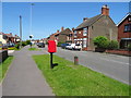
Melbourne Road, Ibstock
The A447.
Showing position of Postbox No. LE67 230.
See Image] for postbox.
Image: © JThomas
Taken: 27 Jun 2019
0.10 miles
5

Elizabeth II postbox on Melbourne Road, Ibstock
Postbox No. LE67 230.
See Image] for context.
Image: © JThomas
Taken: 27 Jun 2019
0.11 miles
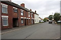
6
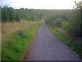
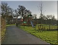
Path down to the ponds
Straight path leading directly south-west down the hill to the large ponds at the bottom.
Image: © Trevor Rickard
Taken: 15 Aug 2009
0.12 miles