IMAGES TAKEN NEAR TO
Hogarth Road, COALVILLE, LE67 5GF
Introduction
This page details the photographs taken nearby to Hogarth Road, LE67 5GF by members of the Geograph project.
The Geograph project started in 2005 with the aim of publishing, organising and preserving representative images for every square kilometre of Great Britain, Ireland and the Isle of Man.

There are currently over 7.5m images from over14,400 individuals and you can help contribute to the project by visiting https://www.geograph.org.uk
Image Map
Images are licensed for reuse under creativecommons.org/licenses/by-sa/2.0
Notes
- Clicking on the map will re-center to the selected point.
- The higher the marker number, the further away the image location is from the centre of the postcode.
Image Listing (16 Images Found)
Images are licensed for reuse under creativecommons.org/licenses/by-sa/2.0
Image
Details
Distance
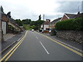
2
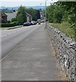
Leicester Road in Whitwick
Close to the entrance to Forest Rock Wood.
Image: © Mat Fascione
Taken: 26 Jun 2010
0.08 miles
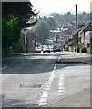
4
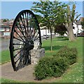
The Whitwick Colliery Winding Wheel
Located along the strangely named City of Dan. Also see: Image
Image: © Mat Fascione
Taken: 9 Jun 2007
0.14 miles
6
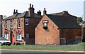
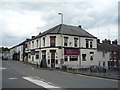
The Three Horseshoes, Whitwick
This Grade II listed public house is more commonly known as 'Polly's'
Image: © Mat Fascione
Taken: 9 Jun 2007
0.16 miles
7
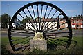
Whitwick Colliery Winding Wheel
Whitwick Colliery opened in 1826 and closed in 1986. After closure (obviously) the winding wheel was erected as a permanent memorial on the Leicester Road.
Image: © Les Carruthers
Taken: 21 Sep 2006
0.18 miles
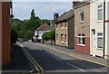
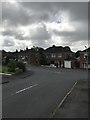
9
Castle Street, Whitwick
Looking north west.
Image: © JThomas
Taken: 21 Jul 2016
0.20 miles