IMAGES TAKEN NEAR TO
Abbey Road, COALVILLE, LE67 4UA
Introduction
This page details the photographs taken nearby to Abbey Road, LE67 4UA by members of the Geograph project.
The Geograph project started in 2005 with the aim of publishing, organising and preserving representative images for every square kilometre of Great Britain, Ireland and the Isle of Man.

There are currently over 7.5m images from over14,400 individuals and you can help contribute to the project by visiting https://www.geograph.org.uk
Image Map
Images are licensed for reuse under creativecommons.org/licenses/by-sa/2.0
Notes
- Clicking on the map will re-center to the selected point.
- The higher the marker number, the further away the image location is from the centre of the postcode.
Image Listing (17 Images Found)
Images are licensed for reuse under creativecommons.org/licenses/by-sa/2.0
Image
Details
Distance
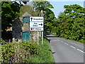
2
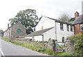
Stone barn at St Joseph's along Abbey Road
Image: © Mat Fascione
Taken: 2 Jan 2017
0.01 miles

5
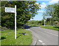
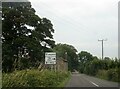
Signpost at Abbey Road Oaks Road junction
Image: © Mat Fascione
Taken: 26 May 2013
0.04 miles
8
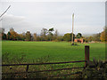
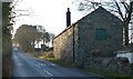
St Joseph's Close, Charley
A special field between the Oaks and Abbey Roads that was a top secret RAF outstation in World War II. The brick structure sheltered a transmitter caravan radiating signals to interfere with Luftwaffe target beams. Other transmitters were in temporary wooden huts.
Image: © Terry Sheppard
Taken: 31 Oct 2009
0.07 miles
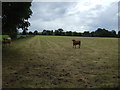
9
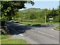
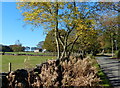
Abbey Road at Oaks in Charnwood
The small hill in the distance is Ives Head (201m).
Image: © Mat Fascione
Taken: 26 May 2013
0.08 miles