IMAGES TAKEN NEAR TO
Rochdale Crescent, COALVILLE, LE67 4TJ
Introduction
This page details the photographs taken nearby to Rochdale Crescent, LE67 4TJ by members of the Geograph project.
The Geograph project started in 2005 with the aim of publishing, organising and preserving representative images for every square kilometre of Great Britain, Ireland and the Isle of Man.

There are currently over 7.5m images from over14,400 individuals and you can help contribute to the project by visiting https://www.geograph.org.uk
Image Map
Images are licensed for reuse under creativecommons.org/licenses/by-sa/2.0
Notes
- Clicking on the map will re-center to the selected point.
- The higher the marker number, the further away the image location is from the centre of the postcode.
Image Listing (11 Images Found)
Images are licensed for reuse under creativecommons.org/licenses/by-sa/2.0
Image
Details
Distance
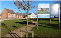
2
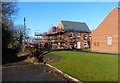
New houses at Abbots View
A new housing development at Agar Nook, on the edge of Coalville.
Image: © Mat Fascione
Taken: 2 Jan 2017
0.16 miles
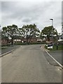
4
Abbots View at Agar Nook, Coalville
A new housing development on the edge of Coalville.
Image: © Mat Fascione
Taken: 2 Jan 2017
0.19 miles
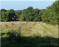
7
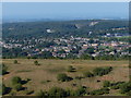
View towards Agar Nook from Bardon Hill
Image: © Mat Fascione
Taken: 29 Sep 2013
0.22 miles
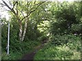
8
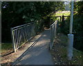
Footbridge along the Ivanhoe Way
This footbridge is at Vercor Close in Agar Nook, the path is heading towards Bardon Hill.
Image: © Mat Fascione
Taken: 29 Sep 2013
0.23 miles
9
Path heading towards Vercor Close in Agar Nook
Image: © Mat Fascione
Taken: 29 Sep 2013
0.23 miles