IMAGES TAKEN NEAR TO
Castle Rock Drive, COALVILLE, LE67 4SE
Introduction
This page details the photographs taken nearby to Castle Rock Drive, LE67 4SE by members of the Geograph project.
The Geograph project started in 2005 with the aim of publishing, organising and preserving representative images for every square kilometre of Great Britain, Ireland and the Isle of Man.

There are currently over 7.5m images from over14,400 individuals and you can help contribute to the project by visiting https://www.geograph.org.uk
Image Map
Images are licensed for reuse under creativecommons.org/licenses/by-sa/2.0
Notes
- Clicking on the map will re-center to the selected point.
- The higher the marker number, the further away the image location is from the centre of the postcode.
Image Listing (9 Images Found)
Images are licensed for reuse under creativecommons.org/licenses/by-sa/2.0
Image
Details
Distance
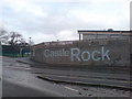
2
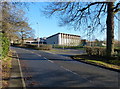
Castle Rock High School
Along Meadow Lane in Coalville.
Image: © Mat Fascione
Taken: 2 Jan 2017
0.12 miles
3
Schools In
A new school, Castle Rock High school was rebuilt in a stunning new design during 2006, replacing the old drab building which was just a couple of hundred metres to the east.
Image: © cris sloan
Taken: 31 Dec 2006
0.12 miles
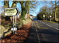
6
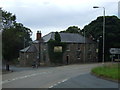
The Forest Rock Hotel, Leicester Road
Located at a very busy road junction.
Image: © Mat Fascione
Taken: 9 Jun 2007
0.19 miles
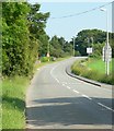
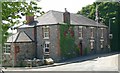
7
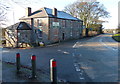
The Forest Rock Offices
A former pub on the corner of Leicester Road and Meadow Lane near Whitwick.
Image
Image: © Mat Fascione
Taken: 2 Jan 2017
0.20 miles