IMAGES TAKEN NEAR TO
Hall Gate, COALVILLE, LE67 4JB
Introduction
This page details the photographs taken nearby to Hall Gate, LE67 4JB by members of the Geograph project.
The Geograph project started in 2005 with the aim of publishing, organising and preserving representative images for every square kilometre of Great Britain, Ireland and the Isle of Man.

There are currently over 7.5m images from over14,400 individuals and you can help contribute to the project by visiting https://www.geograph.org.uk
Image Map
Images are licensed for reuse under creativecommons.org/licenses/by-sa/2.0
Notes
- Clicking on the map will re-center to the selected point.
- The higher the marker number, the further away the image location is from the centre of the postcode.
Image Listing (4 Images Found)
Images are licensed for reuse under creativecommons.org/licenses/by-sa/2.0
Image
Details
Distance
2
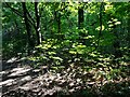
Light and Shade, Bardon Hill
Near Coalville this path leads to/ from Bardon Hill. It was a lovely morning.
Image: © David Bremner
Taken: 21 Jul 2021
0.20 miles
4
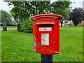
Post Box on Greenhill Road, Coalville
LE67 47. A fine Type M box listed by Royal Mail as Agar Nook.
Image: © David Bremner
Taken: 21 Jul 2021
0.22 miles