IMAGES TAKEN NEAR TO
LE67 3GD
Introduction
This page details the photographs taken nearby to LE67 3GD by members of the Geograph project.
The Geograph project started in 2005 with the aim of publishing, organising and preserving representative images for every square kilometre of Great Britain, Ireland and the Isle of Man.

There are currently over 7.5m images from over14,400 individuals and you can help contribute to the project by visiting https://www.geograph.org.uk
Image Map
Images are licensed for reuse under creativecommons.org/licenses/by-sa/2.0
Notes
- Clicking on the map will re-center to the selected point.
- The higher the marker number, the further away the image location is from the centre of the postcode.
Image Listing (6 Images Found)
Images are licensed for reuse under creativecommons.org/licenses/by-sa/2.0
Image
Details
Distance
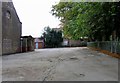
2
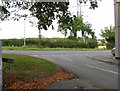
St Mary's Lane/Leicester Road Junction
Image: © Andrew Tatlow
Taken: 19 Sep 2011
0.18 miles

5
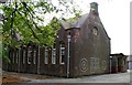
Snibston Primary School
Snibston Primary School combined with Ravenstone Primary School in 2005 to form Woodstone Primary School in new premises on the outskirts of Ravenstone.
Image: © Andrew Tatlow
Taken: 19 Sep 2011
0.20 miles
6
Snibston Primary School playground
Snibston Primary School combined with Ravenstone Primary School in 2005 to form Woodstone Primary School in new premises on the outskirts of Ravenstone.
Image: © Andrew Tatlow
Taken: 19 Sep 2011
0.20 miles