IMAGES TAKEN NEAR TO
Dennis Street, COALVILLE, LE67 2FP
Introduction
This page details the photographs taken nearby to Dennis Street, LE67 2FP by members of the Geograph project.
The Geograph project started in 2005 with the aim of publishing, organising and preserving representative images for every square kilometre of Great Britain, Ireland and the Isle of Man.

There are currently over 7.5m images from over14,400 individuals and you can help contribute to the project by visiting https://www.geograph.org.uk
Image Map
Images are licensed for reuse under creativecommons.org/licenses/by-sa/2.0
Notes
- Clicking on the map will re-center to the selected point.
- The higher the marker number, the further away the image location is from the centre of the postcode.
Image Listing (18 Images Found)
Images are licensed for reuse under creativecommons.org/licenses/by-sa/2.0
Image
Details
Distance
1
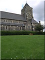
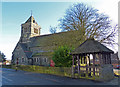
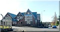
St John's
St John's Church in Hugglescote.
Image: © Michael Patterson
Taken: 24 May 2006
0.02 miles
3
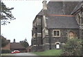
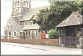
St. John the Baptist Church
This is the south side of the church.
Image: © Steve Rowe
Taken: 8 Sep 2007
0.05 miles
5
St. John the Baptist Church in Hugglescote
Image: © Mat Fascione
Taken: 8 Feb 2015
0.06 miles
6
St. John the Baptist Church
Grange Road, Hugglescote
Image: © Steve Rowe
Taken: 8 Sep 2007
0.06 miles
8
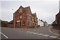
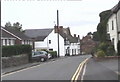
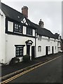
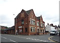
Hugglescote Social Club
On Station Road, Coalville.
Image: © Ian S
Taken: 27 Jul 2021
0.09 miles
10
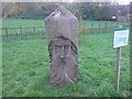
Blockhead
'Green Man' style carving in the grounds of Donington le Heath Manor House
Image: © cris sloan
Taken: 14 Nov 2006
0.16 miles