IMAGES TAKEN NEAR TO
Reg's Way, COALVILLE, LE67 1UA
Introduction
This page details the photographs taken nearby to Reg's Way, LE67 1UA by members of the Geograph project.
The Geograph project started in 2005 with the aim of publishing, organising and preserving representative images for every square kilometre of Great Britain, Ireland and the Isle of Man.

There are currently over 7.5m images from over14,400 individuals and you can help contribute to the project by visiting https://www.geograph.org.uk
Image Map
Images are licensed for reuse under creativecommons.org/licenses/by-sa/2.0
Notes
- Clicking on the map will re-center to the selected point.
- The higher the marker number, the further away the image location is from the centre of the postcode.
Image Listing (6 Images Found)
Images are licensed for reuse under creativecommons.org/licenses/by-sa/2.0
Image
Details
Distance
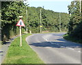
1
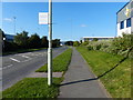
Regs Way on the Bardon Industrial Park
Image: © Mat Fascione
Taken: 29 Sep 2013
0.07 miles
3
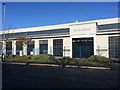
Roca Group building
This is a lot older than I thought: Image
A pleasing bit of Art-Deco pastiche fronting a standard big white box.
Image: © David Lally
Taken: 30 Nov 2019
0.17 miles
4
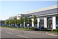
Brantano Footwear Building
The area has been developed into the Interlink Business Park. This building is typical of the type: all aluminium and tinted glass giving no clue as to what goes on inside.
Image: © Les Carruthers
Taken: 21 Sep 2006
0.23 miles
5
Beveridge Lane on the Bardon Industrial Park
Image: © Mat Fascione
Taken: 29 Sep 2013
0.23 miles
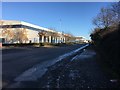
6
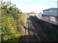
Freight railway from Leicester to Burton upon Trent
Image: © Tim Glover
Taken: 19 Oct 2018
0.25 miles