IMAGES TAKEN NEAR TO
Bardon Road, COALVILLE, LE67 1TD
Introduction
This page details the photographs taken nearby to Bardon Road, LE67 1TD by members of the Geograph project.
The Geograph project started in 2005 with the aim of publishing, organising and preserving representative images for every square kilometre of Great Britain, Ireland and the Isle of Man.

There are currently over 7.5m images from over14,400 individuals and you can help contribute to the project by visiting https://www.geograph.org.uk
Image Map
Images are licensed for reuse under creativecommons.org/licenses/by-sa/2.0
Notes
- Clicking on the map will re-center to the selected point.
- The higher the marker number, the further away the image location is from the centre of the postcode.
Image Listing (12 Images Found)
Images are licensed for reuse under creativecommons.org/licenses/by-sa/2.0
Image
Details
Distance
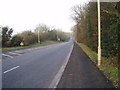
1
The A511 Bardon Road
Heading east towards junction 22 of the M1 Motorway.
Image: © Mat Fascione
Taken: 29 Sep 2013
0.10 miles
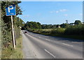
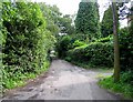
2
The A511 heading towards Bardon
The A511 - the main road between Coalville and Leicester - looking north west.
Image: © Robert Pugsley
Taken: 26 Jan 2007
0.14 miles
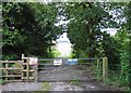
3
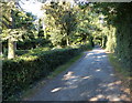
Road to Bardon Hill Quarry
Also leading to the car park for St Peter's Church.
Image: © Mat Fascione
Taken: 29 Sep 2013
0.18 miles
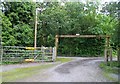
8
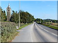
Heading east along the A511 Bardon Road
On the left is St Peter's Church in Bardon.
Image: © Mat Fascione
Taken: 29 Sep 2013
0.21 miles
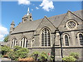
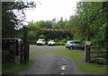
9
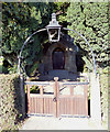
Entrance to St Peter's Church in Bardon
Image: © Mat Fascione
Taken: 29 Sep 2013
0.22 miles