IMAGES TAKEN NEAR TO
Exmoor Close, COALVILLE, LE67 1FP
Introduction
This page details the photographs taken nearby to Exmoor Close, LE67 1FP by members of the Geograph project.
The Geograph project started in 2005 with the aim of publishing, organising and preserving representative images for every square kilometre of Great Britain, Ireland and the Isle of Man.

There are currently over 7.5m images from over14,400 individuals and you can help contribute to the project by visiting https://www.geograph.org.uk
Image Map
Images are licensed for reuse under creativecommons.org/licenses/by-sa/2.0
Notes
- Clicking on the map will re-center to the selected point.
- The higher the marker number, the further away the image location is from the centre of the postcode.
Image Listing (11 Images Found)
Images are licensed for reuse under creativecommons.org/licenses/by-sa/2.0
Image
Details
Distance
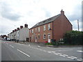
2

Edge of Town
This new housing marks the current western boundary of Ellistown.
Image: © Michael Patterson
Taken: 24 May 2006
0.14 miles
5
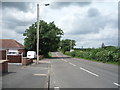
Midland Road, Ellistown
Looking north west.
Image: © JThomas
Taken: 21 Jul 2016
0.15 miles
7
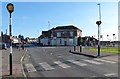
Zebra crossing on Midland Road in Ellistown
In the background is the former and now closed New Ellistown public house, it has a sold sign on it.
Image: © Mat Fascione
Taken: 8 Feb 2015
0.20 miles
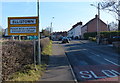
8
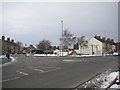
Mini roundabout and village green, Ellistown
Perhaps "village white" would be more appropriate today. The roundabout is at the junction of Whitehill Road (foreground), Ibstock Road (left) and Midland Road (right).
Image: © Richard Vince
Taken: 27 Mar 2013
0.22 miles
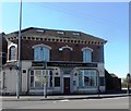
10
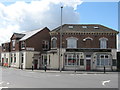
Ellistown New Ellistown Pub/Hotel
Whitehill Road.
Image: © the bitterman
Taken: 21 Jul 2010
0.23 miles