IMAGES TAKEN NEAR TO
Heath Road, COALVILLE, LE67 1DL
Introduction
This page details the photographs taken nearby to Heath Road, LE67 1DL by members of the Geograph project.
The Geograph project started in 2005 with the aim of publishing, organising and preserving representative images for every square kilometre of Great Britain, Ireland and the Isle of Man.

There are currently over 7.5m images from over14,400 individuals and you can help contribute to the project by visiting https://www.geograph.org.uk
Image Map
Images are licensed for reuse under creativecommons.org/licenses/by-sa/2.0
Notes
- Clicking on the map will re-center to the selected point.
- The higher the marker number, the further away the image location is from the centre of the postcode.
Image Listing (6 Images Found)
Images are licensed for reuse under creativecommons.org/licenses/by-sa/2.0
Image
Details
Distance
1
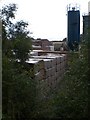
Brick stocks at Hanson brickworks near Merry Lees
Image: © Evan
Taken: 7 Sep 2008
0.01 miles
2
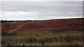
Disused clay pit near Merry Lees
This former clay pit is due to be restored to make a recreational and environment-friendly site on the edge of the National Forest.
Image: © John Welford
Taken: 21 Aug 2015
0.16 miles
3
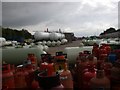
Flogas gas bottling plant at Merry Lees
This is a shot of the northern end of the gas bottling plant taken from the public path that runs to the south of the Hanson brickworks
Image: © Evan
Taken: 7 Sep 2008
0.17 miles
4
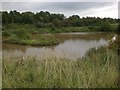
Pool near Hanson brickworks, Merry Lees
This pool, used by fishermen, seems to be fed from run off from the Hanson brickworks. After heavy rain, the water is quite muddy.
Image: © Evan
Taken: 7 Sep 2008
0.17 miles
5
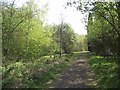
Footpath through Bagworth Heath Woods
This country park is part of the National Forest
Image: © Tim Glover
Taken: 19 Apr 2017
0.18 miles
6
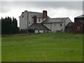
Heath Farm near Merry Lees
Heath Farm taken from southern end of the Hanson brickworks.
Image: © Evan
Taken: 7 Sep 2008
0.19 miles