IMAGES TAKEN NEAR TO
Station Terrace, COALVILLE, LE67 1BD
Introduction
This page details the photographs taken nearby to Station Terrace, LE67 1BD by members of the Geograph project.
The Geograph project started in 2005 with the aim of publishing, organising and preserving representative images for every square kilometre of Great Britain, Ireland and the Isle of Man.

There are currently over 7.5m images from over14,400 individuals and you can help contribute to the project by visiting https://www.geograph.org.uk
Image Map
Images are licensed for reuse under creativecommons.org/licenses/by-sa/2.0
Notes
- Clicking on the map will re-center to the selected point.
- The higher the marker number, the further away the image location is from the centre of the postcode.
Image Listing (20 Images Found)
Images are licensed for reuse under creativecommons.org/licenses/by-sa/2.0
Image
Details
Distance
1
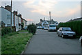
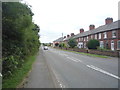
Station Terrace, Bagworth
The Maynard Inn straight ahead. This road used to lead to the old Bagworth and Ellistown Station. Although the single track railway is still there, the station has long gone.
Image: © Kate Jewell
Taken: 16 Oct 2006
0.03 miles
2
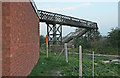
Footpath over the railway
The old Bagworth Station footbridge now carries a public footpath, to Bagworth Wood, over the single track line.
Image: © Kate Jewell
Taken: 16 Oct 2006
0.04 miles
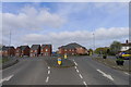
3
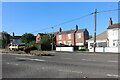
Station Road, Bagworth
The traffic island diverts the road to the new roundabout on the left of it serving the new housing estate.
Image: © David Howard
Taken: 11 Aug 2024
0.04 miles
5
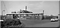
Bagworth & Ellistown Station
View of station exterior (Down side): Leicester - Burton-on-Trent line, now freight-only; station closed (and passenger services withdrawn) September 1964.
Image: © Ben Brooksbank
Taken: 24 Apr 1961
0.04 miles
7

Footpath to Bagworth Wood
From the old bridge, looking towards the young trees of Bagworth Wood, part of the National Forest scheme.
Image: © Kate Jewell
Taken: 16 Oct 2006
0.05 miles
8
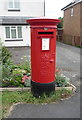
Elizabeth II postbox on Station Road, Ellistown
Postbox No. LE67 259.
See Image] for context.
Image: © JThomas
Taken: 21 Jul 2016
0.05 miles
9
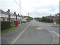
Station Road, Ellistown
Showing position of Postbox No. LE67 259.
See Image] for postbox.
Image: © JThomas
Taken: 21 Jul 2016
0.05 miles
10
Station Road, Bagworth
Looking south east.
Image: © JThomas
Taken: 21 Jul 2016
0.08 miles