IMAGES TAKEN NEAR TO
Main Street, COALVILLE, LE67 1AH
Introduction
This page details the photographs taken nearby to Main Street, LE67 1AH by members of the Geograph project.
The Geograph project started in 2005 with the aim of publishing, organising and preserving representative images for every square kilometre of Great Britain, Ireland and the Isle of Man.

There are currently over 7.5m images from over14,400 individuals and you can help contribute to the project by visiting https://www.geograph.org.uk
Image Map
Images are licensed for reuse under creativecommons.org/licenses/by-sa/2.0
Notes
- Clicking on the map will re-center to the selected point.
- The higher the marker number, the further away the image location is from the centre of the postcode.
Image Listing (60 Images Found)
Images are licensed for reuse under creativecommons.org/licenses/by-sa/2.0
Image
Details
Distance
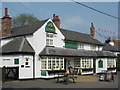
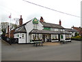
2
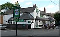
The Bricklayers Arms
Public House on Main Street in Thornton, Leicestershire.
Image: © Mat Fascione
Taken: 29 Jul 2007
0.08 miles
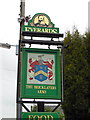
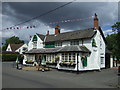
4
Thornton Bricklayers Arms
213 Main Street. Everards pub.
Image: © the bitterman
Taken: 23 May 2012
0.12 miles
7

Hawthorne Drive
Road sloping down in a westerly direction before making a right hand 'hook' at the far end. Modern housing and lots of parked vehicles. Entrance to Beech Drive on the left.
Image: © Trevor Rickard
Taken: 30 Oct 2010
0.13 miles
8
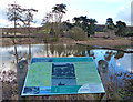
Information board at Thornton Reservoir
Overlooking the weir at the north-west corner of the reservoir.
Image: © Mat Fascione
Taken: 19 Jan 2014
0.15 miles
9
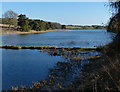
The western arm of Thornton Reservoir
Thornton Reservoir has a surface area of 75 acres and a perimeter of 2.45 miles (3.94 km). It was originally built in 1854 when it had its own treatment works which were situated to the south of the current dam. It is now owned by Severn Trent and the water is treated a few miles away at Cropston Reservoir.
Image: © Mat Fascione
Taken: 25 Feb 2018
0.16 miles
10
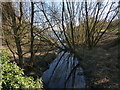
Stream feeding into Thornton Reservoir
At the tip of the western arm of the reservoir.
Thornton Reservoir has a surface area of 75 acres and a perimeter of 2.45 miles (3.94 km). It was originally built in 1854 when it had its own treatment works which were situated to the south of the current dam. It is now owned by Severn Trent and the water is treated a few miles away at Cropston Reservoir.
Image: © Mat Fascione
Taken: 25 Feb 2018
0.17 miles