IMAGES TAKEN NEAR TO
Church Lane, COALVILLE, LE67 1AA
Introduction
This page details the photographs taken nearby to Church Lane, LE67 1AA by members of the Geograph project.
The Geograph project started in 2005 with the aim of publishing, organising and preserving representative images for every square kilometre of Great Britain, Ireland and the Isle of Man.

There are currently over 7.5m images from over14,400 individuals and you can help contribute to the project by visiting https://www.geograph.org.uk
Image Map
Images are licensed for reuse under creativecommons.org/licenses/by-sa/2.0
Notes
- Clicking on the map will re-center to the selected point.
- The higher the marker number, the further away the image location is from the centre of the postcode.
Image Listing (76 Images Found)
Images are licensed for reuse under creativecommons.org/licenses/by-sa/2.0
Image
Details
Distance
2
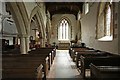
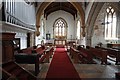
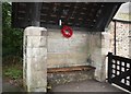
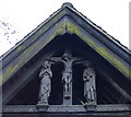
Tucked away
The entrance to St Peters Church at Thornton.
Image: © cris sloan
Taken: 18 Jul 2007
0.01 miles
3
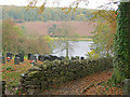
St Peter's cemetery
The cemetery straddles the path down to Thornton Reservoir. Browns Wood in the background.
Image: © Trevor Rickard
Taken: 30 Oct 2010
0.01 miles
4
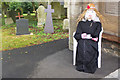
Ecclesiastical scarecrow, Thornton
An entrant for the Thornton scarecrow festival taking tea at the gate to St Peter's churchyard.
Image: © Jim Barton
Taken: 16 Sep 2019
0.02 miles
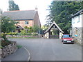
5
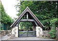
Lych gate at St Peter's Church, Thornton
Image: © Mat Fascione
Taken: 19 Jan 2014
0.02 miles