IMAGES TAKEN NEAR TO
Burroughs Road, LEICESTER, LE6 0XZ
Introduction
This page details the photographs taken nearby to Burroughs Road, LE6 0XZ by members of the Geograph project.
The Geograph project started in 2005 with the aim of publishing, organising and preserving representative images for every square kilometre of Great Britain, Ireland and the Isle of Man.

There are currently over 7.5m images from over14,400 individuals and you can help contribute to the project by visiting https://www.geograph.org.uk
Image Map
Images are licensed for reuse under creativecommons.org/licenses/by-sa/2.0
Notes
- Clicking on the map will re-center to the selected point.
- The higher the marker number, the further away the image location is from the centre of the postcode.
Image Listing (9 Images Found)
Images are licensed for reuse under creativecommons.org/licenses/by-sa/2.0
Image
Details
Distance
1
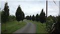
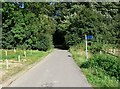
A fairly new avenue
The approach to Old Hays Farm
Image: © John Welford
Taken: 13 Jul 2016
0.09 miles
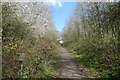
2
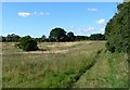
Public Footpath in the Ratby Burroughs
Image: © Mat Fascione
Taken: 29 Jul 2007
0.10 miles
4
Ivanhoe Trail and Burroughs Road at the Ratby Burroughs
Image: © Mat Fascione
Taken: 25 Feb 2018
0.19 miles
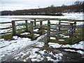
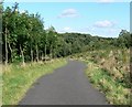
5
The Ivanhoe Trail
A cycle trail that passes through the Ratby Burroughs.
Image: © Mat Fascione
Taken: 29 Jul 2007
0.19 miles
6
The Ivanhoe Trail
A cycle trail passing through the Ratby Burroughs.
Image: © Mat Fascione
Taken: 29 Jul 2007
0.20 miles
7
Old Hayes Wood
Part of the National Forest at the Ratby Burroughs.
Image: © Mat Fascione
Taken: 25 Feb 2018
0.20 miles

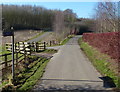
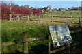
9
Cycle Route 63 climbing up through Burroughs Wood
Passing a Woodland Trust welcome sign
Image: © Tim Heaton
Taken: 6 Apr 2019
0.23 miles