IMAGES TAKEN NEAR TO
Heathbrook Drive, LEICESTER, LE6 0XB
Introduction
This page details the photographs taken nearby to Heathbrook Drive, LE6 0XB by members of the Geograph project.
The Geograph project started in 2005 with the aim of publishing, organising and preserving representative images for every square kilometre of Great Britain, Ireland and the Isle of Man.

There are currently over 7.5m images from over14,400 individuals and you can help contribute to the project by visiting https://www.geograph.org.uk
Image Map
Images are licensed for reuse under creativecommons.org/licenses/by-sa/2.0
Notes
- Clicking on the map will re-center to the selected point.
- The higher the marker number, the further away the image location is from the centre of the postcode.
Image Listing (22 Images Found)
Images are licensed for reuse under creativecommons.org/licenses/by-sa/2.0
Image
Details
Distance
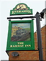
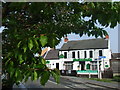
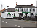
5
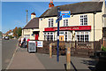
The Railway Inn, Ratby
The inn was originally the booking office for the Leicester to Swannington railway from 1832, as noted by the blue plaque by the red door.
Image: © Jim Barton
Taken: 14 Sep 2019
0.12 miles

8
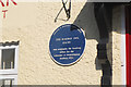
Plaque on the Railway Inn, Ratby
A closer view of the plaque in view on Image
Image: © Jim Barton
Taken: 14 Sep 2019
0.12 miles
9
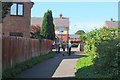
Cyclepath at Station Road, Ratby
The Ivanhoe Trail / Comet Trail meets Station Road close to the Railway Inn.
Image: © Jim Barton
Taken: 14 Sep 2019
0.13 miles
10
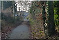
The Ivanhoe Trail in Ratby
This footpath and cycleway follows the course of the former Leicester to Swannington Railway.
Image: © Mat Fascione
Taken: 27 Dec 2016
0.13 miles