IMAGES TAKEN NEAR TO
Lee Rise, LEICESTER, LE6 0NX
Introduction
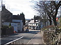
This page details the photographs taken nearby to Lee Rise, LE6 0NX by members of the Geograph project.
The Geograph project started in 2005 with the aim of publishing, organising and preserving representative images for every square kilometre of Great Britain, Ireland and the Isle of Man.

There are currently over 7.5m images from over14,400 individuals and you can help contribute to the project by visiting https://www.geograph.org.uk
Image Map
Images are licensed for reuse under creativecommons.org/licenses/by-sa/2.0
Notes
- Clicking on the map will re-center to the selected point.
- The higher the marker number, the further away the image location is from the centre of the postcode.
Image Listing (21 Images Found)
Images are licensed for reuse under creativecommons.org/licenses/by-sa/2.0
Image
Details
Distance
3
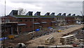
Wagtail Close, Ratby
Although not officially Wagtail Close at the time of submission. These are the first houses to be finished, on the south side of the road that will be named Wagtail Close, presumably soon after the first residents move in. The houses are level 4 sustainable, and built by a local developer with a commitment to sustainability.
Image: © Colin Hoskins
Taken: 6 Apr 2012
0.19 miles