IMAGES TAKEN NEAR TO
Nook Close, LEICESTER, LE6 0JW
Introduction
This page details the photographs taken nearby to Nook Close, LE6 0JW by members of the Geograph project.
The Geograph project started in 2005 with the aim of publishing, organising and preserving representative images for every square kilometre of Great Britain, Ireland and the Isle of Man.

There are currently over 7.5m images from over14,400 individuals and you can help contribute to the project by visiting https://www.geograph.org.uk
Image Map
Images are licensed for reuse under creativecommons.org/licenses/by-sa/2.0
Notes
- Clicking on the map will re-center to the selected point.
- The higher the marker number, the further away the image location is from the centre of the postcode.
Image Listing (46 Images Found)
Images are licensed for reuse under creativecommons.org/licenses/by-sa/2.0
Image
Details
Distance
1
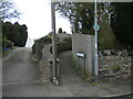
Cottagers Walk, Ratby
A footpath off Church Lane.
Image: © Richard Vince
Taken: 1 Apr 2023
0.05 miles
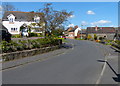
2
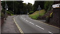
Main St, Ratby
Looking towards the Markfield Road roundabout
Image: © John Welford
Taken: 13 Jul 2016
0.07 miles
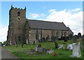
3
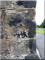
OS benchmark - Ratby, St Philip & St James church
An OS cutmark at the base of the church tower; originally levelled at 102.364m above Ordnance Datum Newlyn.
Image: © Richard Law
Taken: 28 Jul 2015
0.07 miles
4
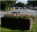
Flowers in Ratby village
The mini roundabout is at the junction of the Main Street, Markfield Road, and Groby Road.
Image: © Mat Fascione
Taken: 27 Jul 2014
0.07 miles
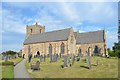
5
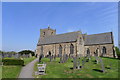
Church of St Philip and St James, Ratby
13th to 15th century, with 18th century restoration. Built with the local Mountsorrel 'granite'.
Image: © Tim Heaton
Taken: 19 Apr 2019
0.07 miles
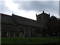
9
Ratby Church
Spend ages with a friend looking for a known gravestone which displays a trace fossil. This fossil along with others was found in 1992 and proved the Swithland slate wasn't Pre-Cambrian. However after much looking it wasn't found. More examples are in Swithland churchyard.
Image: © Ashley Dace
Taken: Unknown
0.09 miles
10
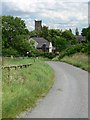
Ratby from Burroughs Road
Looking towards the tower of St Philip & St James Church. The Plough Inn is the building below the church.
Image: © Mat Fascione
Taken: 7 Jul 2007
0.09 miles