IMAGES TAKEN NEAR TO
Berrys Lane, LEICESTER, LE6 0JA
Introduction
This page details the photographs taken nearby to Berrys Lane, LE6 0JA by members of the Geograph project.
The Geograph project started in 2005 with the aim of publishing, organising and preserving representative images for every square kilometre of Great Britain, Ireland and the Isle of Man.

There are currently over 7.5m images from over14,400 individuals and you can help contribute to the project by visiting https://www.geograph.org.uk
Image Map
Images are licensed for reuse under creativecommons.org/licenses/by-sa/2.0
Notes
- Clicking on the map will re-center to the selected point.
- The higher the marker number, the further away the image location is from the centre of the postcode.
Image Listing (42 Images Found)
Images are licensed for reuse under creativecommons.org/licenses/by-sa/2.0
Image
Details
Distance
2
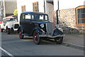
1937 Ford on Main Street, Ratby
I think it's a Prefect, the later model didn't have separate wheel arches and running boards.
Image: © David Howard
Taken: 2 Jul 2023
0.05 miles
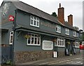
4
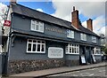
The Bulls Head in Ratby
An Everards public house along the Main Street of Ratby village.
Image: © Mat Fascione
Taken: 24 Feb 2024
0.05 miles
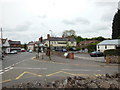
5
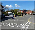
The Main Street in Ratby
At the junction with Berry's Lane, on the left is The Bull's Head public house.
Image: © Mat Fascione
Taken: 15 Apr 2014
0.05 miles
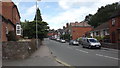
9
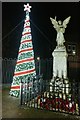
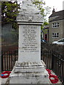
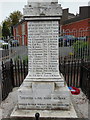
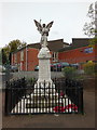
War memorial and christmas tree
Along the Main Street in Ratby.
Image: © Mat Fascione
Taken: 27 Dec 2019
0.06 miles
10
The Bulls Head along the Main Street, Ratby
Image, taken 13 years earlier.
Image: © Mat Fascione
Taken: 13 Aug 2020
0.07 miles